Table des matières
Hornstrandir 2018
Fljótavík project | From 2018/06/24 to 2018/07/06 (13 days)
operating instructions
Various functions are available as part of the map.
mouse/touch operation
- moving by grabbing the map with a mouse-click you can move the map around
- overview map using the < button in the bottom right of the map you can expand an overview map
- zooming in and out using the + and - buttons in the top left of the map you can obtain more or less detail in the map
- switching themes or maps clicking on the ≡ icon on the right-hand side of the map you can view and select available maps and themes
- retrieving information the map may contain elements that contain more information, by clicking these a popup will show this information
- fullscreen display using the ⛶ button the map can be maximized to fullscreen display, use the ▢ button to return to page display.
keyboard operation
Keyboard operation becomes available after activating the map using the tab key (the map will show a focus indicator ring).
- moving using the arrow keys you can move the map
- overview map using the + button in the bottom right of the map you can expand an overview map
- zooming in and out using the + and - buttons in the top left of the map or by using the + and - keys you can obtain more or less detail in the map
- switching themes or maps clicking on the ≡ icon on the right-hand side of the map you can view and select available maps and themes
- retrieving information the map may contain elements that contain more information, using the i key you can activate a cursor that may be moved using the arrow keys, pressing the enter will execute an information retrieval. press the i or the escape key to return to navigation mode
- fullscreen display using the ⛶ button the map can be maximized to fullscreen display, use the ▢ button to return to page display.
It's possible that some of the functions or buttons describe above have been disabled by the page author or the administrator
Intro
English version coming soon…
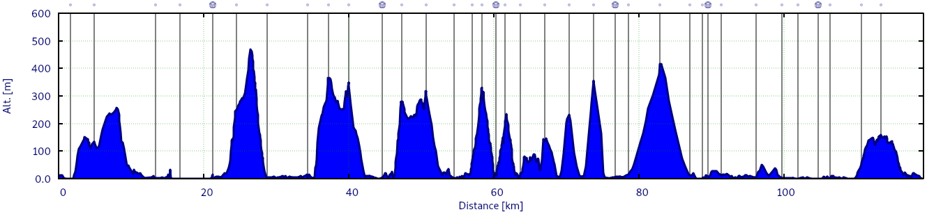
Route
Facts & figures:
- 120 kilometers
- 3930 vertical meters
- 7 stages
- 20 kilos in backpack
D0 - Prologue
2018/06/23 | Alpe d'Huez - Grenoble
- English version coming soon…
D1 - Travel hell
2018/06/24 | Grenoble - Lyon Part-Dieu - Paris Charles de Gaulle Airport - Keflavík Airport - Reykjavík Domestic - Ísafjörður Airport - Tungudalur
- English version coming soon…


D2 - Hornstrandir!
2018/06/25 | Tungudalur - Ísafjörður - Hesteyri - Camp 1
- English version coming soon…


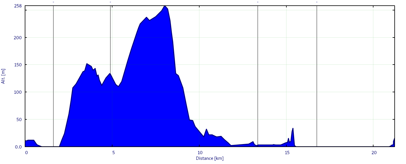
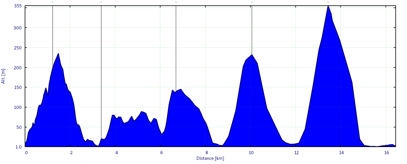
D3 - No turning back (stage 1)
2018/06/26 | Camp 1 - Waypoint - Waypoint - Waypoint - Waypoint - Camp 2


Stage profile:
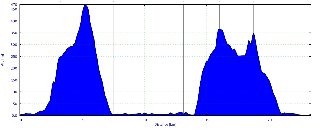
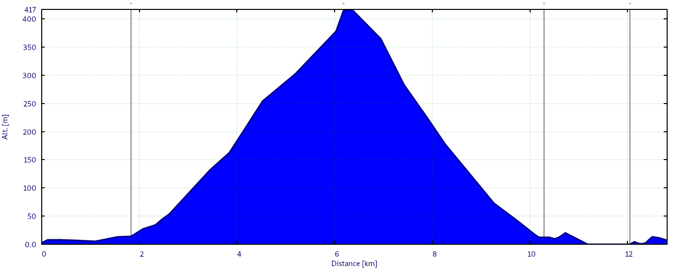
D4 - Marathon (stage 2)
2018/06/27 | Camp 2 - Waypoint - Waypoint - Waypoint - Waypoint - Waypoint - Camp 3
- English version coming soon…


Stage profile:
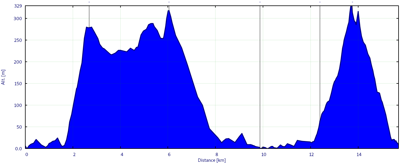
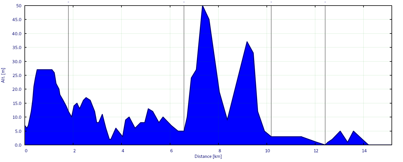
D5 - Truffade day (stage 3)
2018/06/28 | Camp 3 - Waypoint - Waypoint - Waypoint - Waypoint - Waypoint - Camp 4
- English version coming soon…


Stage profile:
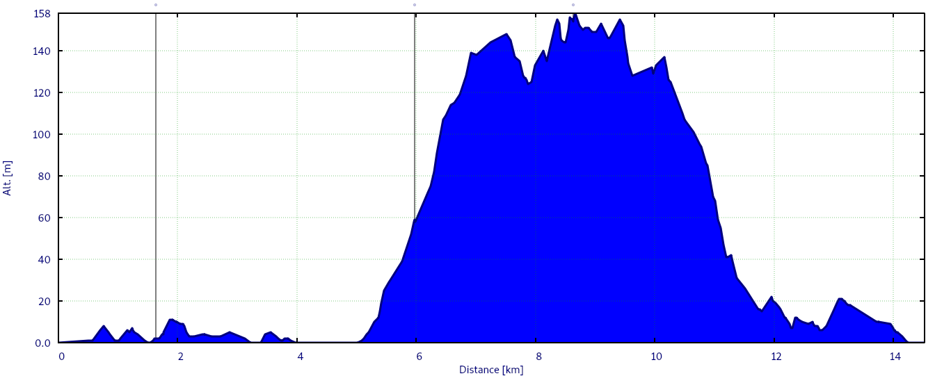
D6 - Roller coasters (stage 4)
2018/06/29 | Camp 4 - Waypoint - Waypoint - Waypoint - Waypoint - Waypoint - Camp 5
- English version coming soon…


Stage profile:
D7 - Blindly (stage 5)
2018/06/30 | Camp 5 - Waypoint - Waypoint - Waypoint - Waypoint - Camp 6
- English version coming soon…


Stage profile:
D8 - Commando (stage 6)
2018/07/01 | Camp 6 - Waypoint - Waypoint - Waypoint - Waypoint - Camp 7
- English version coming soon…


Stage profile:
D9 - The end of wandering (stage 7)
2018/07/02 | Camp 7 - Waypoint - Waypoint - Waypoint - Camp 8
- English version coming soon…


Stage profile:
D10 - Grunnavík
2018/07/03 | Camp 8
- English version coming soon…


D11 - Back to Earth
2018/07/04 | Camp 8 - Ísafjörður - Tungudalur
- English version coming soon…


D12 - The long way home (1)
2018/07/05 | Tungudalur - Ísafjörður - Ísafjörður Airport - Reykjavík Domestic - Reykjavík
- English version coming soon…


D13 - The long way home (2)
2018/07/06 | Reykjavík - Keflavík Airport - Lyon Airport - Grenoble - Alpe d'Huez
- English version coming soon…